


Doucy Savoie 74 Les Charmettes

ARPF
User
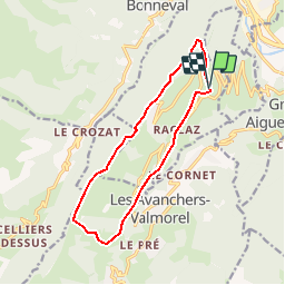

Length
12.6 km

Max alt
1564 m

Uphill gradient
710 m
Km-Effort
22 km

Min alt
960 m

Downhill gradient
714 m
Boucle
Yes
Creation date :
2019-01-15 12:54:58.629
Updated on :
2019-01-15 12:54:58.629
4h28
Difficulty : Medium

FREE GPS app for hiking
 SityTrail
IGN / Geographical institutes
SityTrail Plus
The world is yours!
About
Trail Walking of 12.6 km to be discovered at Auvergne-Rhône-Alpes, Savoy, La Léchère. This trail is proposed by ARPF.
Positioning
Country:
France
Region :
Auvergne-Rhône-Alpes
Department/Province :
Savoy
Municipality :
La Léchère
Location:
Unknown
Start:(Dec)
Start:(UTM)
302487 ; 5042103 (32T) N.
Comments